
High-tech drone survey and GIS mapping of properties in Raipur
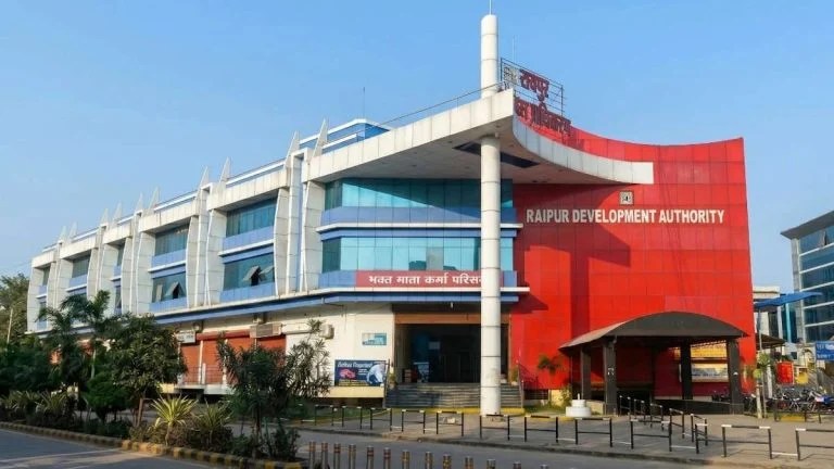
Raipur, September / The Raipur Development Authority (RDA) is embarking on a major technological initiative to modernize, transparently, and effectively manage its properties, plots, residential and commercial projects, and public infrastructure. This initiative will include GIS-based asset mapping, high-tech drone surveys, digitization of old records, and the development of a digital monitoring system throughout the authority's jurisdiction. The authority has completed the tender process for the project's implementation.
This ambitious project will preserve decades-old paper records, property registers, ledger books, layout maps, and lease and lease documents in high-quality digital format. High-resolution surveys and mapping will be conducted using cutting-edge drone technology to link these records to the actual situation on the site.
*Every asset will have a unique digital identity*
Under the project, each RDA property and plot will be assigned a Unique Property Identification Number (UPIN). The UPIN will be linked to the respective property's digital record and GIS map. This will organize property-related information on a unified and secure digital platform, laying a strong foundation for future online citizen services.
The survey will not be limited to aerial mapping, but will also include on-site physical verification of properties. Trained survey teams will conduct door-to-door surveys and digitally collect geo-tagged photographs and essential property information through a mobile app. The information obtained during the survey will be compared with historical records and drone mapping.
*Benefits will extend from property management to citizen services*
The creation of a GIS-based digital database will provide RDAs with more systematic information regarding the location, boundaries, measurements, and use of properties. This will facilitate record verification, property management, and monitoring. Comparing the situation on the ground with available records will also help identify unauthorized encroachments and land-related discrepancies.
The integrated digital platform will help make future citizen services such as mutations, lease renewals, building permits, and NOCs more streamlined, transparent, and online. The availability of property boundaries, measurements, and record information in one place will also facilitate the resolution of property disputes.
Along with this, availability of GIS based digital information of public infrastructure like roads, drains, drainage, street lights and water supply will enable their maintenance, monitoring and future development plans to be prepared more effectively.
The ambitious project will be completed in six phases.
This RDA project will be carried out in six major phases. The first phase will involve scanning and digitizing old records, registers, ledger books, and maps. The second phase will involve high-resolution mapping of the area using high-precision drones.
In the third phase, trained survey teams will conduct door-to-door physical verification, and in the fourth phase, geo-tagged photographs and essential property data will be collected through a mobile app. In the fifth phase, data from historical records, drone surveys, and physical verification will be integrated into a GIS platform. In the final phase, the generated digital database will be securely hosted and assets will be monitored and managed through web-based asset management software.
*Important step towards good governance: Housing and Environment Minister Shri O.P. Chaudhary*
Housing and Environment Minister Mr. O.P. Choudhary said that under the guidance of Chief Minister Mr. Vishnu Dev Sai, the Chhattisgarh government is continuously moving forward to promote digitization in citizen services. This initiative by the Raipur Development Authority to digitize properties and records, conduct drone surveys, and utilize GIS mapping will prove to be an important step towards good governance. This will increase transparency in the Authority's operations and lay the foundation for providing better and more convenient services to citizens in the future.
*Property management will be modern and technology based: Shri Nand Kumar Sahu*
Raipur Development Authority Chairman Mr. Nand Kumar Sahu said that this is an important initiative towards making the management of properties and projects modern, transparent, and technology-based. Through GIS mapping and digital records, property information will be more organized and secure.
RDA Vice Chairman Dr. J.P. Sharma said the authority's goal is to provide more convenient, transparent, and timely services to citizens in the future and ensure better management of RDA properties. The use of new technology will help streamline property-related processes.
*RDA will have a comprehensive digital asset database: Shri Avnish Kumar Sharan*
Raipur Development Authority Chief Executive Officer Mr. Awanish Kumar Sharan said that the project will scientifically document the ground situation by linking the RDA's historical records to a digital database. Drone surveys, geo-tagging, physical verification, and GIS-based data integration will create a comprehensive digital asset database for the Authority's properties and infrastructure. This will help make asset management, record verification, monitoring, and citizen services more efficient and streamlined.
Appeal to citizens to cooperate with the survey team
The Raipur Development Authority has appealed to citizens to provide necessary information and cooperate with the measurement work when the authorized survey team arrives at their premises. Authorized employees engaged in the survey work will be required to have an ID card issued by the RDA.
.jpg "CHHATTISGARH: Ex-IRS Sheetal Shaswat Verma, who has taken VRS, gets a big responsibility!")






.jpeg "A New Milestone in Good Governance : CM Helpline Becomes the Voice of the People, Over 92,000 Complaints Registered and More Than 42,000 Grievances Resolved in Just One Month,48 Government Departments on a Single Platform; Raipur Leads Among Districts, Energy Department Tops in Grievance Redressal")